<< Back to Articles Index page
Castle Dyke & Grimsbury
Castle Dyke
In The History of Chudleigh (1852 and 1875), Mary Jones wrote: 'the attention of the reader has to be directed to the Danish Encampment, on the heights of Ugbrooke Park. This was probably occupied by the Danes about the year 876, as at that time they overran the southern part of the county'.
A Chudleigh guide book (c1972) says of Castle Dyke within Ugbrooke park that
'there is an old fortification of earthworks built by the Dumnonii in 200BC, known locally as the 'Danish Encampment', for although originally built for inter-tribal warfare, it was used as a centre if the Danes raided up the River Exe or Teign. It has an inner and outer circle, they put their women and children in the inner circle; in the outer circle their cattle, leaving behind a defence platoon.'
The Chudleigh Book (2009) suggests that it was likely that the first hillfort was developed during the Bronze Age but evidence of this being lost due to a later Iron Age fort at the same place. The defended settlement with an oval bank and ditch enclosed an area of some 200m x 300m with a dyke around the perimeter, hence its name.
An early description in the National Gazeteer (1868) runs as follows:
'an entrenchment 3/4m. SE in Ugbrooke park. It consists of a single agger, and fosse, involving an irregular oval area of about 2 1/2 acres. An outwork, a vallum and foss 400 yards long perhaps defended a spring to the south of the camp. The origin may have been British, but the place was probably strengthened by the Romans. The Roman road from Exeter to Cornwall, the Icknield Way, passes to the east of the camp, and on this side was one of the chief entrances.'
However, it must be said that the reference to Icknield Way is not correct, as this road ran between Wiltshite and Norfolk; it was the Fosse Way which ran from Lincoln to Exeter. Any road going beyond Exeter – evidence exists (e.g. see The Chudleigh Book) but is fragmentary – might be considerd to be a B-road extension to the A-road Fosse. Not only that, but there is no visible evidence of Roman occupation and as there would be no strategic value in this site, at most it might have been an temporary (overnight) Roman camp.
Today, Castle Dyke is on private land, part of the Ugbrooke Estate and so not acessable withput permission from the land owner. However, part of the outer bank can just be made out through the trees from the Gappah Ridge road which runs along the western edge of the estate.
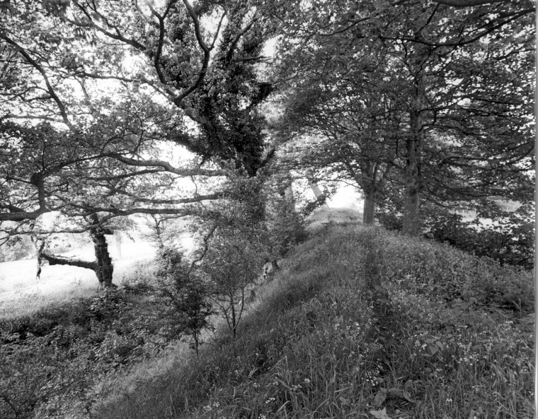
Castle Dyke bank & ditch (1965)
Some other photos of Castle Dyke may be seen on (for instance) the The Megalithic Portal website
Grimsbury
In the Chudleigh section of Place Names in Devon it contains the name Grimsbury. It indicates that the name 'Grim' was associated with the monster Grendel of the Beowulf story. Grimspound on Dartmoor was middle bronze age (1500–1250 BCE). Hoskins' Devon (under Manaton) says Grim 'undoubtedly refers to the Devil'. He also said 'this (Grimspound) is one of several well-known sites where a large prehistoric work was associated by the Saxons with diabolic forces.'
The Place Names of Devon goes on to say that Grimsbury (now lost) was Grendelbury (1330 Subsidy Roll), Grendelesbury (1333 Subsidy Roll); other spellings noted up to 1779 were Greenbury, Grinsbury and Grimsbury. 'Bury' in this context means fort so we potentially have the Saxons referring to Castle Dyke as the 'devil's fort'.
The following extract is from the Grimspound page of the Legendary Dartmoor website.
"Everybody is entitled to their opinion and so firstly, Other Dartmoor occurrences of the ‘Grim’ element are the Grimslake, Grim’s Grave, whilst looking further afield there is Grims Dyke, Grimesthorpe, Grimsbury, Grimsby, and Grims Ditch. To be more specific, ‘Grim‘ comes from the old Norse word Grimr which was an alternative name for Odin. It also referred to a ‘masked’ person or one who conceals his name both of which Odin was renown for, Ekwall, 1980, p.205. The opinion of The Place-Name Society is that the ‘Grim‘ element is an Anglo Saxon word for the Devil and that this appendage was given to any old prehistoric site which they regarded as having diabolical associations, Gover et al, 1992, p. 482. This may well be that the Saxons adapted the word and substituted the Devil for Odin. However, if one consults Clark Hall’s venerable tome, he suggests that the Saxon word grimm means fierce or savage, (2004, p.160) so could the place name refer to the ‘settlement of the savage tribe’?"
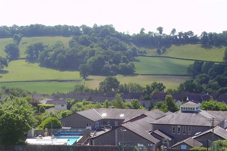
This photograph, taken from the church tower in 2010, shows the primary school
in the foreground.
To the rear is the ridge that separates Ugbrooke Park from the town and
just over the ridge is the site of Castle Dyke.
The clump of trees to the middle is Target Wood that roughly marks the location
of the former Grimsbury.