<< Back to Articles Index page
The Town Leat (Pot Water)
Tradition has it that the Town Leat (or Pot Water) had its origin at the time of the episcopy of Edmund Lacy, ordained as Bishop of Exeter in 1420 and who died at his palace at Chudleigh in 1455. It seems more likely that originally, rather than an open leat it was a piped supply constructed at the time of Bishop John Grandisson (1327–1369). In his will he stated that Chudleigh was his favourite residence and as he had overseen the overhaul of the piped supply to Exeter Cathedral (1346/48) it seems probable that it was he instead that was responsible for its construction. It may be that Bishop Lacy carried out improvements during his time as bishop some sixty years later.
The watercourse ran for six miles from its source; a spring at Oxencombe in the north of the parish to the entrance to the town and then on to the palace grounds to the south of the town. At its destination it no doubt fed a fountain at the palace and additionally supplying large fishponds of carp, eventually draining into the Kate Brook near Palace Mill. It was a major piece of construction and must have taken many man hours to complete. If its primary purpose in its earliest form was to provide clean spring water to the palace then it seems reasonable to assume that it was originally piped throughout its length (as it was at Exeter). With the demise of the palace in the mid-1500s the pipes were probably replaced by an open leat in its passage from Oxencombe to the town.
As with Exeter the supply was not just for the bishop's use. The facility was made available to the inhabitants to 'dip' into the supply as required at points along its route. The mere fact of dipping suggests the water was covered and/or piped at an early date.
As the years passed additional channels were added along its route through the town. In the old records the word 'shute' is often mentioned, originally of wooden and later stone construction they were basically a method of channelling the water, as an aquaduct, to change direction of the flow or direct the water to a particular property. Flat stones with small circular holes bored through them were also used to regulate the amount of water flowing to a particular user.
As already mentioned dipping pits were created at intervals along its route to provide access to the water flowing beneath. Four such public pits survive (although long closed off); three in New Exeter Street and one in the lower part of Clifford Street. A further pit was located in the front boundary wall of the Old House in Fore Street and some remains of its stonework can be seen immediately beside the entrance driveway (demolished c1966). Another was located in Old Exeter Street, just above the tannery (today the entry to Tannery Mews) but no evidence of this pit exists today.
The winding journey of almost six miles from its source to what is now Highlands Park remained virtually unchanged down the years and principally was an open channel of about three feet in depth. Its twisting route was necessitated by the fact that it had to follow the contours of the land. Where lanes needed to be crossed flagstones would be laid over the top. In more recent times these covered channels were replaced with either 6, 8 or 12 inch socket pipes.
From the spring at Oxencombe the leat crossed under Rock Lane and flowed on to Marsh Lane where it then turned a sharp right-angle to the west and flowed along almost the length of the lane until turning south to enter Rowell Wood. On leaving the wood a shute in later times diverted water down to Rowell Cottages (today Highwayman's Haunt restaurant). The leat continued on its way passing under Milestone Lane then to and through the grounds of Filleigh (where it later supplied a swimming pool), Oakfield (where it supplied a fern grotto in Victorian times) and on through the grounds of Heathfield House. At the latter, again following the contours of the land it veered to the right to flow out to the top of Heathfieldlake Hill (much later the site of Syon Abbey). In more recent times this section was piped. From the abbey (built 1887) the course moved roughly north-westward through to the area called Heathfield Lakes in former times. The course here was particularly ingenious as steps had to be taken to take the leat over the naturally occurring Buddle (Bottle) Brook and old records (1601) mention a 'shute' to convey the water, in effect an aquaduct. An almost 180 degree turn brought the flow to the other side and above the brook to flow on to the path-field that was in the 1930s developed as Highlands Park (formerly Boyerhole Meadow).
In its earliest form the leat arrived at the top of Exeter Way (Old Exeter Street) and flowed straight down the hill to the original market place – later marked by the obelisk. More recently, and at the entrance to what is now Highlands Park, a diverting chamber was constructed, the old stout door of which can still be seen. The purpose of this chamber was to split the flow into three directions:
[1] The main flow continued down Exeter Way (now Old Exeter Street) to a dipping pit at the corner of the southern boundary wall of Arne – formerly the Congregational Manse (no evidence of this pit remains) – then provided a source to the nearby tannery and from there out into The Square. There a flow was taken via a shute to provide a supply to a drinking trough for animals. This was later removed and the supply diverted to a conduit at the obelisk. The water then crossed the Square underground to continue its way to the Bishops Palace.
[2] The second channel flowed down (and parallel) to Colway Lane to a dipping pit (still extant) at the top of Culver Street (New Exeter Street today), outside the old Baptist Chapel (now Brookfield Flats) and from there crossing Culver Street and running down its length toward the town, supplying two more dipping pits (located in the Culver House boundary wall) on its way to the junction of Mill Lane (Clifford Street) with The Square. A supply was taken into Culver House grounds for domestic use and from the early 1850s the water also serviced a fern grotto, the large boulders of which are still extant close to the childrens play area in what is now called Culver Green. At the entrance to Mill Lane at The Ship Inn the water, now flowing south-east naturally found its way downhill, originally in an open channel alongside the fronts of the cottages to serve another dipping pit just beyond the turning to Parkway Road. Eventually the water after passing Town Mills drained out into the Kate Brook close to Bridgelands Bridge.
[3] The third flow exited the diverting chamber and traversed land now occupied by Newinnton Lodge, initially piped and then an open stream to an outlet located in the wall at the higher part of Wood Way (now Woodway Street) and from there crossing under the lane and draining into the field opposite and finding its way downhill, skirting the Great Hill field and finally wending its way into the Teign.
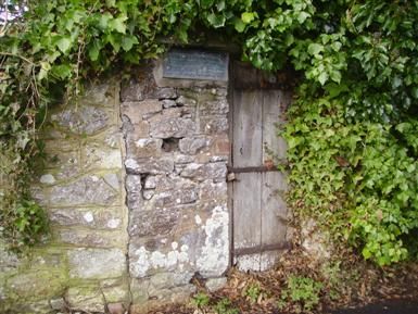
Door to Diverting Chamber, Old Exeter Street
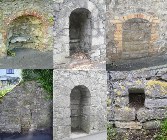
Pot water dipping places
Top row L-R:
top of Old Exeter Street (outside Brookfields Court) [4];
middle of Old Exeter Street (boundary wall of Culver house) [5];
lower Clifford Street [8]
Bottom row L-R:
Fore Street (outside The Old House) [11];
bottom of Old Exeter Street (boundary wall of Culver house) [6];
The Old Water Spout (shute), Woodway Street [2]
Numbers in square brackets refer to the location on the map below
Returning to the vicinity of The Ship Inn the main channel having passed the tannery in Old Exeter Street continued its flow under The Square to continue behind the properties lining the east side of Fore Street. These properties had their long gardens (the original medieval burgage plots) and the leat traversed these roughly at right angles moving in the direction of the Play Park. In at least three gardens a dipping pit was dug (that of numbers 14, 23 and 24 Fore Street); at Alpha House an ornamental pond was fed and at Swanston House a shell grotto. Additionally in this area the water could well have been channelled off via shutes for domestic or industrial use at other nearby properties.
Passing through the gardens of Swanston House – where the shell grotto was later sited (against the southern boundary wall with Vicarage Lane, of which slight evidence remains) ‐ the stream passed under Vicarage Lane and through the Play Park, at this point wholly underground. Through the park (where a dipping pit was sited) it then ran along the boundary hedge of a field called Lawn, in effect parallel to – but some yards from – the lane that much later became called Parade. As the stream, once again an open channel, approached Rock Road it veered to the left and downhill to supply the bishop's ponds mentioned earlier. These ponds were drained many years ago, their site reverting to field use. The pot water, having turned away from the back of the Parade followed field hedges across the land called Palace Meadows and came out at Palace Mill. Having passed under the lane it followed parallel to the north side of the mill building and drained into the Kate Brook via a small waterfall. In more recent times the leat was also directed straight toward Rock Road and the water made to issue from a spout in the wall opposite Palace Farm.
In the year 1601 a dividing chamber was constructed within what was then the Play Park, this chamber later fell within the boundary of the one acre site sold off (1668) for the building of Pynsent's Grammar School (now The Old House). This general area was referred to as the shutelands. The purpose of this dividing chamber was to take a new channel out to Fore Street – where a dipping pit was much later created (this pit was removed in 1966 when the entrance driveway to the Old House was built but the remains can still be seen in the wall and are marked with an Amenity Society tablet) – where it crossed under the road and down into 'the old way', later Pottery Lane and now Old Way. The junction of Fore Street with the old way was at that time referred to as The Western End. In the old way the leat flowed down into the two fields called Moor's Meadow and Great Hill. In 1597 a plot of ground in the old way had been purchased by the parish on which the almshouse was erected in 1611, this building replacing an earlier one on the site used for the same purpose. The channel down the old way was an open leat until piped in the early 1900s.
Close to the entrance of the old way another branch from the leat was made at right angles to cross the road and to supply an already existing pond that was roughly located at the top corner of the Skaigh premises, a single garage marks its spot today. From there the open leat continued southward behind what are now the gardens of the houses in the Parade. These houses, including the current vicarage house were built on a field called Fair Park, that had for many years been in use for the annual fairs, hence the need for this particular channel. Eventually this source, following the contours of the land would have found its way down behind Pound Meadow and eventually out into the Teign. The pond was almost opposite a building that from about 1597 was rented by the parish for use as an almshouse. This building was rented from either John Keene (or John Reeve) who in the old records is described as being of 'Poole'. There is nowhere in Chudleigh of that name and it is now thought that the 'pool' in question was another name for the pond opposite his premises.
From its early days the leat was in the care of the churchwardens who would, on 22 May each year appoint a leat committee who in turn would nominate an attendant whose job it was to ensure the continual flow of water whatever the prevailing conditions. His payment was paid out of the rate levied on those who benefitted from a supply of water from the leat. In the early 1600s the rate was 6d a year for those with a regular supply but it seems that all users were not necessarily liable to pay.
For example, in 1621 there was an inquiry into the use of the pot water and it was agreed by the committee that it should be allowed free to the Old Place (formerly the Bishop's Palace) and Mr. Vaughan's house through a 1-inch hole. It was also allowed free to Mr. John Reeve's house at Poole, to the shute at the Western End of town but all others to take through a half-inch hole and pay yearly for it to the churchwardens.
In more recent times the responsibility for the upkeep of the leat passed to the parish council who continued to appoint an attendant annually. In 1947 responsibility for the upkeep passed to the Newton Rural District Council and it was reported in the press at the time that there had never been so much trouble with the leat, in 1950 the council complained that the leat was costing more than £100 a year. The efforts of the leat attendant remained paramount who had an often difficult task in keeping the leat flowing. Sometimes there were disagreements and petty disputes between various parties along its route – occasionally the leat would run dry and sometimes flooding of property would occur due to blockages of one sort or another. Damage by animals was often another problem in the higher reaches of its course. The role of leat attendant continued until the summer of 1952 and with no more regular upkeep the leat literally sank into repose and was no longer treated by the council as a viable entity.
All these events were finally consigned to the history books in 1973 after the opening of the A38 dual carriageway. That new route had severed the leat in three locations and as these were never rejoined it brought a final conclusion to an engineering feat that had stood the test of time for 543 years.
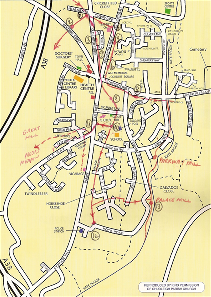
A current street plan of the town showing the routes of the town leat.
Key:
1. The site of the original divding chamber and the
1866 reservoir
2. The shute in Woodway Street
3. Site of former tap in Old Exeter Street
4. Dipping pit outside the Brookfield Flats, New
Exeter Street
5. Dipping pit Herridge Orchard wall, New Exeter
Street
6. Dipping pit Culver House boundary wall, New Exeter
Street
7. Site of former tannery, Old Exeter Street
8. Dipping pit, Clifford Street (formerly Mill
Lane)
9. Dipping pits in the gardens of Fore Street
properties
10. Location of former dividing chamber (now lost
under Lawn Gardens development)
11. Site of former dipping pit located in the Old
House boundary wall
12. The former shute in Rock Road (no evidence now
remains)
13. The termination of the town leat where it joined
the Palace Mill leat
The red line (north/south) from Bridgelands to Palace Mill and
beyond marks the former mill leats, servicing both Parkway and Palace Mills.
For those seeking more detail on this ingenious feat of engineering then it is suggested that Desmond Shears' book 'The History of Chudleigh's Water Supply' is obtained. Published locally, copies are available by ordering a copy via this website. Please send an email via the Contact page to request a copy.